 Live Music Archive
 Librivox Free Audio
 Metropolitan Museum
 Cleveland Museum of Art
 Internet Arcade
 Console Living Room
 Books to Borrow
 Open Library
 TV News
 Understanding 9/11
tv Your Money CNN October 28, 2012 3:00pm-4:00pm EDT
3:00 pm

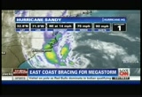
welcome back. i'm fredricka whitfield in atlanta. hurricane sandy is already causing a lot of preparations to get under way all along the east coast, from north carolina up to maine. let's bring you up to date on already some of the cancellations that have been put in place in some of the northeastern cities as well as mid-atlantic. let's focus on new york where already subway and commuter train service has been suspended for tonight. there are mandatory evacuation orders of low-lying areas.
3:01 pm
evacuation centers are going to be open in 72 public schools. you'll have to check your listings locally and port authority says train stations will be closing at midnight, and public schools in new york city will be closed tomorrow. let's move on to now the state of new jersey where a state of emergency has already been declar declared. mandatory evacuations in parts of the state are already under way, and many of the tolls are suspended in the garden state area so that people are able to safely and slowly evacuate. buses are being sent to atlantic city and other low-lying areas to help out in the evacuation. and now we move even further south to the state of maryland where that, too, that state has been declared a state of emergency. voluntary evacuations are already under way in low-lying areas and mandatory evacuations taking place on the coast there in ocean city. and in d.c., public schools have been canceled for tomorrow.
3:02 pm
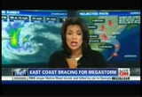
so you've got to check your local listings to make sure you're up to speed on all the cancellations involving your transit, schools, et cetera. chad meyers with us now to give us an idea on where this storm is. still hovering in the north carolina coast? >> still out there. everybody says it's a category 1 with a mid-latitude low. a mid-latitude low that can make a snowstorm all by itself. all of a sudden you have a mid-latitude low. it's called a snowstorm. add a hurricane to it and all of a sudden you have extra charge. one plus one equals three on this one because you're going to get a super low pressure start. even though it's 75 miles an hour, it has the pressure of a category i category 2, category 3 storm. tropical surge 400 miles on both sides of the eye. you're talking an 800-mile
3:03 pm
swath. that can produce gusts strong enough to knock down trees, knock down power lines. it will take a long time to put all this back together if the infrastructure is going to get damaged. there is no question about it. we just hope that you pretend that this thing is not a category 1. just make sure you're thinking of 2-3 as you're making your preps, especially if you're along the coast. >> storm surges, that's where a lot of danger and trouble can result. we're talking about storm surges up to 11 feet in some areas, and people are hearing, oh, category 1, i've been through something like that before, it's no big deal. but when you talk about storm surgeries pretty significant like that along with the winds, power lines down, it's a terrible combination. >> a certainly is not a tsunami. it's not some big wall of water that comes in and washes everything out. this rises over time. we're looking at some of these numbers that are 4 to 6 feet higher than irene in new york
3:04 pm

harbor. >> wow. >> irene didn't make flooding. but if you take irene and add four more feet to the top of that surge, you're well over battery park. you're well up above the seawalls on both the east river and the hudson. then you think about the other side. you think about hoboken, you could get water 12 feet higher than normal. what would that do to the property? what would that do to rthe refineries over there. >> it's been hugging the east coast for a while. are we talking about the del marvo area, is it east of that, or is that the quandary here. >> that's the $60 million question. we know this storm is still going straight. it is not forecast to continue straight. it will turn west and hit the u.s. if it turns quickly it will hit
3:05 pm
the del marvo and truly affect washington, d.c. with a significant bigger punch than is forecast now. >> with hardly any drainage. >> you push that water up to chesapeake and all of a sudden you have a significant basin that will take water and it will go up quickly. that's not the forecast. if it goes up north, it takes longer to turn and then you're piling all that water into long island sound and the east river, and all that water system, they're talking about it right now, they're concerned that the water may go into the new york subway system just like we were concerned in irene, it just didn't happen. this is a more important storm than irene was and irene was a $15 billion event. >> wow. that was significant. that was connecticut hit very hard. >> connecticut, vermont, new hampshire and into new jersey. >> power was out more than a week in some locations. we'll see you again momentarily. let's check in on a state that is feeling the fury of hurricane
3:06 pm
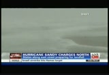
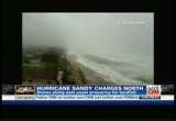
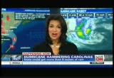
sandy right now, and that's north carolina, the outer banks getting the worst of it. maybe the worst of it is actually hitting our george howell. george, you're in kill devil hills. what's new? >> reporter: you know, let's talk about what's happening here on the outer banks. let's talk about the state of north carolina. when you look at the radar, this is the state. you have 40-plus counties that have all declared states of emergency. when you look at the bands here, the bands on the northwest side of the storm, they are affecting this area, and what you're getting is the strong wind. here we're getting the sideways rain mixed with sand here along the ocean, and i also want to talk about storm surge. chad was talking about that a minute ago. when you look at what's happening back there, fredricka, there was a beach out there yesterday. we walked on the beach. the beach is gone. and the storm surge out here expected to be anywhere from 4 to 6 feet in this area. on the other side of the island, there is a possibility of 3 to 5 feet of flooding.
3:07 pm
people here know the areas that typically flood. they've gotten to higher ground, but everybody is keeping a very close eye on the storm as it passes by this area. >> all right, george. chad meyers still with me now. chad, do you have a question for george? >> what i was mentioned earlier about how irene didn't hit new york city very hard, it didn't hit new york city very hard because it got the stuffing out of it when it hit north carolina. irene really devastated parts of that outer bank. it's still fragile, the sea grass not back where it should be, so any type of surge will quickly erode that beach again. it takes a few years for all that seal to come back and protect it. george, are you expecting that water to come over that barrier island and into the sound behind you? >> reporter: there is a real concern, chad, about the storm surge on this area where we are. obviously 4 to 6 feet, that will cause some flooding and it will get over the water. there is a temporary bridge that
3:08 pm
was washed out from irene. people are worried about that bridge. there is a temporary bridge there now. they're worried about what will happen as we continue to see the ocean push up. they're also worried about all the water, chad, that gets pushed into the sound and then comes back out and causes that flooding on the sound side. we're talking near where we are, kill devil hills area, 3 to 5 feet. the further you go south on this island strand, people concerned that this storm could cause major flooding, major damage. >> george, water you're wiping from your eyes and your face, is it salty water or fresh water? >> reporter: it's salty water and it's also mixed with sand, and i typically like to just see what's coming at me, so i like to keep a good view of what's ahead as best i can. that's why i don't wear the hood. but it's been like this throughout the day sustained, i
3:09 pm

would say. it's been like this, gusts right around 40 miles an hour, stronger gusts, and chad, you were talking about that wind field. we're on the edge of that wind field, so when you think about what's going on closer to the eye and when you think about these hurricane force winds coming into those metropolitan areas, it's definitely something people should take heed of. look what's happening here and definitely take precautions if you live in those areas, new york city, philadelphia, washington, d.c. area. >> you're hundreds of miles from the center, maybe 300, and that's what you're getting. all the rain that's coming down is fresh water. the rain coming out of a hurricane is fresh water. the salt he's tasting is the mist and the spray coming off the foam of the ocean and into his eyes and face. i would appreciate if you get some goggles on, though, sir, it feels like you're getting hit by a sand blaster. please be careful. it will be a longer one tonight and a longer one tomorrow.
3:10 pm
>> george, thank you so much. people are reminded why the outer banks are hit so hard, it's just kind of like a little hook that sticks out. whenever there is a hurricane that hugs the atlantic coast in that area, the outer banks almost always get a brush of it. if they don't get the devastating surge, they at least get the wind and the rain, and that's exactly what we're seeing here. of course, we wish the best for the folks there and the property owners on the outer banks. >> do you see the arm coming out of the center? the center is above the ring in hammering. it's an outer band that is slamming north carolina right now. if you go 50 miles, 60 miles closer to the eye where that band isn't, it's calm. and george wouldn't be feeling anything. so when every band comes by, the weather gets bad. when the band leaves, the weather will improve for 36 more hours. >> chad, we're going to travel north now. let's go to new jersey now, and
3:11 pm
governor chris christie is preparing for the worst there, hoping for the best when it comes to this hurricane. he's doing everything possible to get his state ready. allison kosick is in seabright. we know people are bracing for the worst. in what form? >> reporter: they definitely are preparing, especially as you feel this wind get stronger ask stronger as the day goes into night here. look at the ocean. it is certainly getting angry angryer by the minute. i talked to the sheriff here. he said there are two big concerns for this area. he said the wind and the storm surge which is expected to happen tomorrow when the hurricane does come to shore. the big worry is this whole area will flood. his worry is it will flood anywhere from 3 to 4 feet through here. they got a tape ste of this thi
3:12 pm

morning when high tide happened. over here is seabright, a town where all the stores are, where residents live. they got a taste of high tide. there is a river on the other side of these buildings. it certainly overflowed this morning, gave them a taste of what's to come. it certainly is worrying one store owner i talked with who owns a business that's only been there about two months. she's boarding up and she's concerned. >> i'm a little concerned about this one. everything we've been watching on the news says this one might really get it. we're definitely worried about it, we're worried about our business. i'm worried about our home which is on the other side of the river. but we're doing everything we can to prepare, and hopefully she'll spare us. so we'll see. >> and a little momentlevity as we stand out here. there you see a pumpkin about to get washed out into the ocean.
3:13 pm
every indication that halloween could be a washout. >> i know that little pumpkin will be disappointed about that. chad, when you look at what could potentially come to new jersey, what advice can you give them right now? >> the thing we need to look at is where is the eye going to make landfall. if you're south of that eye and you're boarding up the windows facing the ocean, you're boarding up the wrong side of the house. the winds are going to come from land, not the sea. so 70-mile-an-hour gusts will blow out the wrong side of your house that you're not boarding up. people that think they're doing the right thing sometimes do the wrong thing. i want you to sit down for just ten minutes, think about worst case scenario, what am i forgetting before i leave, and then get out. do the what you forgot and get out. people talk about medicines, right? make sure the medicines that you
3:14 pm
put away for hurricane irene are still good. because if they're expired, then all of a sudden your emergency medications aren't emergency medications anymore. you might have to get a refill sometime today. >> chad, thanks so much. let's move over to new york where the mayor, michael bloomberg, plans to hold a news conference at 4:00 eastern time, about 45 minutes from now. we'll bring that to you live. next i'll talk to a coast guard admiral to find out how they are planning on protecting the nation's ports and waterways all along the east coast ahead of this storm. nyquil (stuffy): hey, tylenol. you know we're kinda like twins.
3:15 pm

tylenol: we are? nyquil (stuffy): yeah, we both relieve coughs, sneezing, aches, fevers. tylenol: and i relieve nasal congestion. nyquil (stuffy): overachiever. anncr vo: tylenol cold multi-symptom nighttime relieves nasal congestion... nyquil cold & flu doesn't. [ female announcer ] at yoplait, we want you to feel even better about your favorite flavors. so when you call, tweet, and post, we listen. that's why yoplait light and yoplait original are now made with no high fructose corn syrup. and why we use only natural colors and natural flavors in yoplait original. so, anything else we can do for you, let us know. but you'll keep it to yogurt, right? 'cause we shouldn't really help with your love life. yoplait. it is so good!
3:16 pm

but what about your wrinkles? neutrogena® rapid wrinkle repair visibly reduces fine lines and wrinkles in just one week. why wait if you don't have to. neutrogena®. [ male announcer ] it's time for medicare open enrollment. are you ready? time to compare plans and see what's new. you don't have to make changes, but it's good to look. maybe you can find better coverage, save money, or both. and check out the preventive benefits you get after the health care law. ♪ medicare open enrollment.
3:17 pm
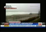
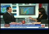
now's the time. visit medicare.gov or call 1-800-medicare. ♪ millions of dollars flowed up and down florida. how are they protecting the seaports from sandy? he is the fifth district commander of the u.s. coast guard. he's joining me on the phone from portsmouth, virginia. so admiral, if there is a way to prepare for this storm, how do you go about this? you're talking about lots of waterways, many ports, you're talking about commerce ships and you're talking about leisure ships, many of whom didn't know this storm was coming. >> certainly, fredricka. we start by being prepared all the time, and really the coast guard really concentrates on
3:18 pm
that, but if you look at this particular storm, it's really been on our radar screen since before last weekend. we flew a search and rescue mission with a c-130 out of north carolina. started down in georgia and went all the way up to new england overflying the waters in the atlantic to warn people about the impending storm. so i think anybody who is u unaware of the storm really hasn't been paying attention. most mariners are pretty well prepared, and we're not so worried about all the mariners. we've warned them pretty well and we've taken action on what we're doing with our ports to ensure that our ports are also going to be safe. >> given that, what's your biggest concern or what's the greatest measure that you're able to take at this juncture? >> well, a lot of people are talking about this storm and saying, is it a hurricane, is it a tropical storm, and from our perspective, it really doesn't matter because sandy has a tremendous amount of energy in
3:19 pm
this system. there is a lot of rain, wind, and depending upon where, when and exactly how it comes ashore, it could be bad or it could be devastating. i've heard other people talk about the storm surge, the tide and how the timing is critical and where you are in relation to the eye, and that's exactly true, but it's so far out that we don't know exactly where it will hit, so i say we need to prepare now. >> and, admiral, meteorologist chad meyers is with me now. he's got a question for you as well. >> we talk about this surge and there's a number 0 to 6, and this surge is over 5.5 which is significant. they think the surge is more important than almost anything else. this surge you're talking about through the chesapeake where you are all the way up and into the del marvo peninsula and into lanew york harbor. if the new york harbor gets a surge of 6 feet or more, what
3:20 pm
happens? >> i'm not an expert on the new york harbor, but i know they're taking steps there and they'll probably talk to you later about the significant steps new york is taking. but depending how and where it hits, it could really be devastating. some of the action we've taken, for instance, off the virginia and maryland coastal areas, we've gone to what we call port condition zulu. we've closed all those ports. no ships are allowed to enter or leave because it's not safe to do so. if the storm goes on, i think those conditions will continue to move up the coast. >> what about retying and double tying ships that come up. >> there are many places where that's being done. the navy here, commander fleet forces, initially was looking at sailing all the navy ships out of here, and based on the projections said, okay, let's hunker down here.
3:21 pm
many of the ships have moved to the safest moorings possible, and we've done the same for our purposes so we can reconstitute immediately after the storm and fall in and figure out where there is trouble and where people need our assistance. >> and admiral, even though you say the notice has been out for at least a week, most mariners would know, and for anyone who wouldn't know that this story was on the way, they perhaps were not paying attention, still do you have a concern there is going to be a certain level of search and rescue you'll have to engage in? >> well, certainly, fredricka. there is always that level of concern. and we get certain types of calls all of the time. sometimes we're able to correlate it to vessels in distress, and sometimes they're not actual vessels in distress. almost all the time we will send somebody to determine what's happening, and if that type of
3:22 pm
situation occurs closer to a storm, we really have to assess the risk and say, are we sure somebody is in distress, and if so, do we have an appropriate asset, either fixed wing or a cutter, that is able to get to the location. >> it's chad again. i just want to get to your explanation about hunkering down ships instead of sending them out. did the size of the wind field being 800 feet across, did you maybe not think you could see fast enough? did that have something to do with it? >> exactly, and if you look at the area where i am, if ships did not set out of port, unless they're very fast ships, they probably needed to leave thursday or early friday, and if they waited until friday evening, they probably couldn't get out ahead of the storm. the danger of getting ahead of the storm is if the seas become rougher, you would not be able
3:23 pm
to make the same speed you would make in calm seas, and if you can't get ahead of the storm or if the storm were, in fact, to head toward the east, you would be in the middle of it and no mariner wants to be in that situation. >> thanks so much for your time over the course of the next few days. >> so many moving parts. so many people depend on the water or are attached to the water in some way, their lives, their jobs, and so is our sandra endo right now. >> that's right, she's in ocean city. apparently that area is being pounded pretty hard right now, including our area with sandra endo. sand sandra, what's happening? >> it's about two hours from high tide right now, but already very rough waves out here and constant, steady wind at about 20 miles an hour, fred and chad,
3:24 pm
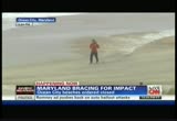
and that's not including the wind gusts which are much more strong. local officials here are just worried about high tide plus the long duration of this 36-hour storm just hovering over this area, pouring down rain, and that's really going to be the big concern, flooding and the storm surge, possible power outages, downed wires as well. that's why they've ordered a mandatory evacuation for downtown ocean city as well as visitors of this area and a voluntary evacuation for low-lying areas. so they're really bracing for hurricane sandy, preparing for the worst, and a lot of residents and businesses are boarding up as well preparing for this storm, but you can see we're already feeling the effects and it's not even close to this area as of yet. so clearly the worst is yet to come. >> right. so many hundreds of miles away from the maryland coast, right? because we've been talking about it being a couple hundred miles off the coast of north carolina.
3:25 pm

so you have to move further north in order to get to that maryland coast. hopefully you didn't lose that hat with all that wind, because last we saw, you were holding onto that hat for dear life. sandra mentioned a lot of those businesses are boarding up. hopefully they're done with boarding up, because at this point it's a little too late to have the semblance of doing that. >> i'll tell you they're done. whether they got all the boards on the house or not, they're done. you cannot handle a 4x8-inch sheet of plywood in that wind. the rip currents that are out there right now are tremendous. the water flying over the sandbars and that water just rushing out to sea, and it would take anybody out there f. you. e if you're on a surfboard, you might have to paddle another mile back to shore and that would be really hard. >> we know it's a dangerous
3:26 pm
storm, potentially dangerous storm. it is still so beautiful and inviting. i spent many of my summer weekends in ocean city, maryland, and very seldom did you get a chance to enjoy that kind of surf. it's gorgeous but it is potentially dangerous. so i'm glad, too, like you, there is no one out there trying to belly board or surf or something of that nature. >> i couldn't afford ocean city, so i had to go to hoboken. >> they're neighbors. that's all one big stretch of beach. thank you, chad. appreciate that. our coverage of hurricane sandy will continue. we expect to hear from mayor bloomberg about 30 minutes away. he'll make preparations for the big apple. it could be such a long night for many east coast cities. we'll bring you up to date. [ male announcer ] citi turns 200 this year.
3:27 pm

in that time there've been some good days. and some difficult ones. but, through it all, we've persevered, supporting some of the biggest ideas in modern history. so why should our anniversary matter to you? because for 200 years, we've been helping ideas move from ambition to achievement. and the next great idea could be yours. ♪ now, thaa test drive.ll silverado! the most dependable, longest lasting, full-size pickups on the road. so, what do you think? [ engine revs ]
3:28 pm

i'll take it. [ male announcer ] it's chevy truck month. just announced additional $750 bonus cash on a 2012 chevy silverado all-star. trade up to get a total value of $8,750. bonus cash ends october 31st.
3:29 pm

at meineke i have options... like oil changes starting at $19.95. my money. my choice. my meineke.
3:30 pm

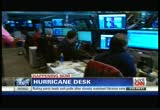
hurricane sandy already causing lots of changes. we've got school closings, we've got closing in transit service and even talking about now broadway going dark. our josh levs is at the hurricane desk with the latest on all of this taking place. josh. >> hi again, fred. so many moving parts to this storm, even before it gets all the way actually to the coast. take a look at where we are right now. we're in the middle of the newsroom and this is now our cnn hurricane desk. we've got teams of people following every state, every city that can and most likely will be impacted by this storm. let me tell you another piece of information that just came in. new jersey is asking the federal government for a pre-landfall emergency declaration. folks, keep this mind the context of this. first of all, the most important thing, keeping everyone safe, having altogether l the resource care of everyone. this is also in the backdrop of an upcoming election. so you've got new jersey having for a pre-landfall emergency
3:31 pm

declaration. you mentioned broadway shows. we have some information about that right now. we have found out broadway shows will be canceled tonight and also tomorrow night. one more thing to let you know here, school closings now covering more and more young people out there. at least 1.8 million kids will be out of school tomorrow. and for everyone else, even if you don't live in that area, you might be impacted because flights will be impacted everywhere. i've got a screen for you here of how many flights will be impacted allov over the country. we've been talking to all the airlines trying to get the latest numbers for you. 1500 flights canceled. delta has not given us a number, but they're telling us all new york flights to philadelphia has been canceled. all flights for new york city and dulles, and now jetblue has canceled more than 1,000 flights. you can expect impacts all over the place. take a look with me here.
3:32 pm
we've been talking about the evacuations in new york city. not everyone is clear if they're in that area or not. i have a map that i linked up from twitter that shows what the evacuation centers are for new york city and we also have information on evacuation centers that people can go to. we have some really powerful photos coming in from ireporters in various parts of the country. folks, if you are in a safe place to take pictures -- look at that, wow -- go ahead and send them to ireports. we'll share some of these amazing photos throughout the evening. >> we were talking to chad meyers earlier, we were talking about the width of this storm. we're talking about 800 miles including the center. on each side more than 400 miles of its wind reach and the potential devastation that comes with it. it's pretty extraordinary. so all up and down the east coast, particularly from north carolina up to the northeast,
3:33 pm
maine, are all bracing for what could come, whether it's storm surges, whether it's rain or whether it's heavy winds that can bring down power lines, et cetera. so these kind of pre-landfall emergency declarations make a whole lot of sense just to keep as many people out of harm's way as they can. >> and people, we all need to cast a really big net in following where this storm could be, and following the officials. coming up, we'll hear from new york city mayor michael bloomberg and hearing how that city is doing. we'll be talking to officials all over the place. i encourage everyone to keep it here. >> we'll catch that live from new york mayor michael bloomberg. you heard josh underscore how many schools are now closed and how many jurisdictions. we're talking millions of kids who will not be in school tomorrow, whether it be in d.c. or other portions of new york, et cetera. we're going to keep an eye on
3:34 pm

all the developments for you as a result of this impending storm. hurricane sandy, after this. rge, high up in the atlas mountains of morocco. have you seen this road we're going down? ♪ there is no relief for the brakes. we'll put them to the test today. all right, let's move out! [ ross ] we're pushing the ats brakes to the limit. going as fast as we can down the hill. we are making these sharp turns, slamming on the brembo brakes. [ derek ] it's like instant response, incredibly consistent. this is the challenge, machine vs. mountain. [ male announcer ] the all-new cadillac ats. this is the challenge, machine vs. ♪ountain. (train horn) vo: wherever our trains go, the economy comes to life. norfolk southern.

3:36 pm

i wish my patients could see what i see. ♪ that over time, having high cholesterol and any of these risk factors can put them at increased risk for plaque buildup in their arteries. so it's even more important to lower their cholesterol, and that's why, when diet and exercise alone aren't enough, i prescribe crestor. in a clinical trial versus lipitor, crestor got more high-risk patients' bad cholesterol to a goal of under 100. [ female announcer ] crestor is not right for everyone. like people with liver disease or women who are nursing, pregnant or may become pregnant. tell your doctor about other medicines you're taking. call your doctor right away if you have muscle pain or weakness, feel unusually tired, have loss of appetite, upper belly pain, dark urine or yellowing of skin or eyes. these could be signs of rare but serious side effects. ♪ is your cholesterol at goal? talk to your doctor about crestor.
3:37 pm

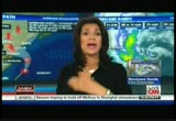
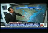
[ female announcer ] if you can't afford your medication, astrazeneca may be able to help. welcome back. i'm fredricka whitfield. welcome back to our continued coverage of hurricane sandy. right now it's a pretty sizeable storm and it's hugging the coast of north carolina. let's bring in our meteorologist chad meyers to discover where it is exactly. its track, its power and its potential. >> it's hundreds of miles from anywhere and we're still feeling the effects, these live pictures on the shore, but we're still 36 hours, maybe less, from making landfall. such an impressive storm because it's so large in size. not because the center of the eye is a category 4, but because the hurricane winds extend so far out from the middle of it, and the tropical storm force winds extend 800 miles in diameter around this thing or across this thing. so that's the potential. it's not that it's a
3:38 pm
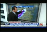
75-mile-per-hour storm, so do not focus on that. you must focus on the size, how long it's been in the water, how low the pressure is and what the tremendous storm surge is going to be as this water piles up along the shores of new jersey and also into new york harbor and the water comes up and over. it could be a little farther south if the storm turns to the left. that would be the chesapeake. so far that's not quite the forecast. the winds of chesapeake should be blowing out to sea. you may actually see some of those eas get lower than normal rather than higher than normal because the surge may actually drag water out of the chesapeake bay. also snow. i have no real number of how much snow could come down. i would easily say 60 inches of snow. >> that is unbelievable. >> just an incredible number, and it's so early in the season, and some of the trees still have leaves on them. so here we go. here's our 6 to 11-foot surge all the way through the sound,
3:39 pm
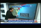
and you have to understand what this water is doing in the east river and up toward the hudson. we could see surgeries of 11 feet. all of this area will be overwashed. all those barrier islands in new jersey, the water will be coming from the ocean, over the sand and into the sound or the area behind it. and then a little bit farther down to the south, 2 to 4 feet. then the surge here, because the wind is already coming on shore here in north carolina, understand that the surge will come up on the coastal seas here of del marvo, but as it comes here, the water will blow out and come out to sea. there are so many moving parts because it's so large. and new hampshire, boston and vermont, if this storm decides not to turn in time, all of a sudden it turns so quickly and
3:40 pm
these things do not work on the computer model because they don't even know we have computer models. if there's something up here, if the storm does get farther north to boston, out of the cone, not out of the question, you could get surges near the cape. that's what the center of the storm looks like. it's a ginormous low pressure center that's going to interact with high pressure in the west -- that's over here -- and wind in indiana could reach 60 to 70 miles per hour. >> even the head of fema said this is a slow-moving storm dumping lots of rain in those areas. gets go to george howell in kill devil hills, and yes, it
3:41 pm
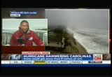
continues. you continue to get pummelled there pretty badly, george. have you seen anybody who has ventured out in your purview? >> no. just us. we're out here, everyone is inside, everyone is making sure to stay out of the way of this thing because it is pretty rough out here. the winds come and go. we've seen gusts 40 miles an hour-plus. and i just spoke with officials of dare county and emergency management, and they said, look, this is going to be a touchy situation through the night. they expect the winds to get stronger. we are on that area of land, that part of the state that juts out into the atlantic. the storm is moving up and then we lose the metropolitan area, but as it gets closer to us, we're getting closer to the stronger winds in that wind field. that's the big worry out here. and also as these winds start to shift. so it was coming to the eafrom
3:42 pm
now it's coming from the north and the south. the problem here, when you start talking about the sound side, that's where you see a lot of flooding where the wind pushes this water around. that's where they see a lot of flooding typically, especially when irene came through. that's what they're worried about here, these low-lying areas prone to flooding. >> you can hear that wind, that rain coming down hard as well. thanks so much, george howell, appreciate that from kill devil hills. our hurricane sandy coverage continues in about 20 minutes or so. for now we're going to hear from new york mayor michael bloomberg update folks on preparations that will take place there.


3:46 pm

zp. both new york and new jersey are taking the threat of hurricane sandy very seriously. the governors and mayors from both states have been keeping everyone posted constantly on preparations, evacuations and closures. we've been monitoring all the states. they've been working closely to make sure all the residents get the word no matter what. >> speaking of the residents, they're experiencing some fatigue. now i think people are thinking where do we need to pay attention to these preparations if last time we didn't get hit as hard. but the mayor stresses there is a difference here. with irene, it was wind and rain that was big, this time it's storm surges. take a listen.
3:47 pm

>> number one, it is unsafe to operate the trains in high winds. second, we don't want the equipment damaged and trains are designed to deal with a lot of tough duty. they are not intended to be submerged. and we don't want to damage the equipment and then have a real problem getting the system up and running. and thirdly, we don't want to encourage people being up and about. we want people staying in their homes, be prepared and stay at home. >> stay at home, prepare, prepare, prepare. there are similar concerns in new jersey as well. chris christie also held a press conference earlier today. but even before that press conference, he stepped out on his twitter to get the word out to that unconventional avenue. he tweeted that new jersey transit will become a gradual systemwide shut down of bus,
3:48 pm

rail and subway service at 2:00 p.m. >> the mayor corey booker had a different message to convey, didn't he? >> yeah, he was very blunt addressing what his personal concern was, and i believe it's first responders, getting them in a more dangerous position than they have to be. he addressed residents direct until his press conference. take a listen to this. >> the biggest concern we have right now is individuals not taking this storm seriously enough. the human error that often comes from a lack of preparation or a lack of sobered understanding of what is going to happen to the state of new jersey. and many of the crises we've had to respond to in the past, most mark people not adequately preparing for the crisis. >> back to new york, fred,
3:49 pm

they're not taking any chances about precautions. they send residents updates to their i phones and their smartphones, talking about these mandatory evacuations we've been talking about in zone a. >> we're going to hear mayor bloomberg in about ten minutes and we'll take you live to that press conference. in the meantime, we're going to hear how new york is preparing for hurricane sandy. oney. [ dog barks ] because right after they get married, they'll find some retirement people who are paid on salary, not commission. they'll get straightforward guidance and be able to focus on other things, like each other, which isn't rocket science. it's just common sense. from td ameritrade.
3:50 pm

it's just common sense. when you take a closer look... ...at the best schools in the world... ...you see they all have something very interesting in common. they have teachers... ...with a deeper knowledge of their subjects. as a result, their students achieve at a higher level. let's develop more stars in education. let's invest in our teachers... ...so they can inspire our students. let's solve this. nyqui tylenol: me, too. and cougnasal congestion.ers? nyquil:what?
3:51 pm

tissue box (whispering): he said nasal congestion... nyquil: i heard him. anncr vo: tylenol cold multi-symptom nighttime relieves nasal congestion... nyquil cold & flu doesn't. that was me... the day i learned i had to start insulin for my type 2 diabetes. me... thinking my only option was the vial and syringe dad used. and me... discovering once-daily levemir® flexpen. flexpen® is prefilled. doesn't need refrigeration for up to 42 days. no drawing from a vial. dial the exact dose. inject by pushing a button. flexpen® is insulin delivery... my way. levemir® (insulin detemir [rdna origin] injection) is a long-acting insulin used to control high blood sugar in adults and children with diabetes and is not recommended to treat diabetic ketoacidosis. do not use levemir® if you are allergic to any of its ingredients. the most common side effect is low blood sugar, which may cause symptoms such as sweating, shakiness, confusion, and headache. severe low blood sugar can be serious and life threatening. ask your healthcare provider about alcohol use, operating machinery, or driving. other possible side effects include
3:52 pm

injection site reactions. tell your healthcare provider about all medicines you take and all of your medical conditions. get medical help right away if you experience serious allergic reactions, such as body rash, trouble with breathing, fast heartbeat, or sweating. with flexpen®... say good night to vial and syringe. ask your doctor about levemir® flexpen. covered by 90% of insurance plans, including medicare. find your co-pay at myflexpen.com. hurricane sand which already brushing parts of the maryland coasts, let's go outside of washington, d.c. to athena jones, outside of indianapolis, maryland. in comparison to what we're seeing in minneapolis city. >> it start started raining here, the wind picking up in the last hour or so.
3:53 pm

we're hearing indianapolis, one of the low-lying areas along the coast. you can see just how close the water already is to street level so it only takes a few inches to send it over. in case there is a storm surge, they were hanged handing out sandbags. he hopes they don't get a big brunt of all this fwloog flooding, but let's listen to what they have so say. >> we're not expecting floods coming in up, but we have sandbags here just in case, which you'll be putting in front of the doors and on the sides there, just to keep heavy, heavy rain blue the building toward the rain. >> we're talking about an ice cream shop that's going to lose
3:54 pm

everything i they have no power for a few days. >> governor o'malley said that early voting for tomorrow for monday will be cancelled. but this is also having wider impacts on the campaign. vice president biden had to cancel an event in virginia on saturday. governor romney cancelled events that was planned for tomorrow. i should also say the romney campaign says they are suspending fundraising e-mails in washington, d.c. d.c., in virginia, pennsylvania, north carolina and new jersey. so big impact on politics. >> the romney camp moving its campaigning, paul ryan and mitt romney to ohio over the next couple of days, but there too, they might find themselves in the middle of a whole lot of snow, while that's expected there, while the east coast deals with a lot of wind,
3:55 pm
rain -- momentarily, maybe about six minutes or so away, we understand the new york mayor of michael bloomberg is expected to have a press conference about the preparations that are under way there. >> let's go to josh levs. >> as we talk about so many moves parts. we're also going to be hearing from the governors of massachusetts and pennsylvania and we'll be bringing you the information that's cing in. everyone you're seeing is in engaged in the process of making calls, reaching out, finding out everything you need to know about what's happening with this storm. i will tell you when i was on with you earlier this hour, we were talking about flight cancellations. we have just gotten another piece of information on that, we are hearing that united airlines has now cancelled about 3,700 flights. we'll keep updating that for you as the time goes along.
3:56 pm
i want you to see these figures that we have here, how many millions of people are already being impacted by the transportation changes in new york as vut of what's being shut down. on a typical day, new york subways has 4.3 million rides. the metropolitan authority has about 8.5 million riders a day. am track's northeast corridor, we do know that 750,000 riders a day generally take that northeast corridor from am track. so you've got a lot of people that are already impacted just in that area alone. before we disappear, two things that you should check out online. if you go to the main page on cnn.com. take a look at the possibilities of how this could -- finally, for those of you on twitter, i have created a twitter list that has officials from all of the states expected to be impacted if you go to my twitter right
3:57 pm

now, josh levs cnn. >> mens away from new york city michael bloomberg, and his preparations from that city, next. and tastes simply delicious. for those of us with lactose intolerance... lactaid® milk. the original 100% lactose-free milk.
3:58 pm

we don't let frequent heartburn come between us and what we love. so if you're one of them people who gets heartburn and then treats day after day... block the acid with prilosec otc and don't get heartburn in the first place! [ male announcer ] one pill each morning. 24 hours. zero heartburn.

182 Views
IN COLLECTIONS
CNN Television Archive
  Television Archive News Search Service
Uploaded by TV Archive on
